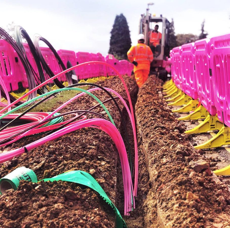
New Digital UK Map of Underground Cables Starts to Go Live

The Government’s new National Underground Asset Register (NUAR), which is a digital UK map of underground pipes (water etc.) and cables (broadband, power etc.) that could help reduce accidental damage, has started to go live for several initial areas under its first deployment phase – covering North East England, Wales and London.
The Government believes there is huge potential for related location data from telecoms, energy, water and other providers, which could be used to improve the way that national infrastructure is planned, built and managed. For example, such data could help to inform where future “gigabit-capable broadband” and 5G mobile networks need to go, as well as planning how and where to connect utilities, and designing new housing developments etc.
One of the ways such a map could help is by reducing the amount of accidental damage that occurs to existing infrastructure, which one estimate suggested could cost up to £2.4bn each year. The Government also suggests that NUAR could deliver “at least” £350m per year of economic growth (due to increased efficiency, reduced asset strikes and reduced disruptions). But this does rather ignore the fact that alternative platforms, such as the LSBUD (Line Search Before You Dig) service, already exist to provide a similar facility.
Nevertheless, the project, which is being developed alongside Ordnance Survey (OS) and Atkins, has made progress and is now starting to go live with data from the public and private sector organisations who own pipes and cables in North East England, Wales and London.
This includes all of the major energy and water providers, such as Northumbrian Water, Wales and West Utilities, Southern Electric Power Distribution and National Grid, as well as smaller providers of these services, telecommunications companies, transport organisations and local authorities.
Dr Steve Unger, Independent Commissioner, Geospatial Commission, said:
“This first release of NUAR is a major milestone in a programme that will benefit everyone. By using the power of location data to plan and deliver street-works more effectively, it will improve the efficiency with which we supply essential services and it will minimise the disruption experienced by other road users.
Many different asset types are buried beneath our feet, owned by many different organisations, large and small. We are delighted by the number of asset owners that have recognized the value of working with us, to make the data that they hold more accessible.
And this release is just the start! Whilst it contains data from over 80 organisations, we have already received data from over 100 more, and we are working with many more than that to progress their involvement in the programme. I urge any asset owner that is not yet engaging with us to do so as soon as possible, to start benefiting from the service and ensure it best meets their needs.”
The first phase is considered to be a Minimum Viable Product (MVP), which will continued to grow and be improved over the next couple of years. Future releases will cover the rest of England and Northern Ireland.


Mark is a professional technology writer, IT consultant and computer engineer from Dorset (England), he also founded ISPreview in 1999 and enjoys analysing the latest telecoms and broadband developments. Find me on X (Twitter), Mastodon, Facebook and Linkedin.


« Ofcom Set to Refer UK Cloud Market for Competition Probe
Latest UK ISP News


- FTTP (5669)
- BT (3552)
- Politics (2585)
- Openreach (2334)
- Business (2311)
- Building Digital UK (2265)
- FTTC (2056)
- Mobile Broadband (2022)
- Statistics (1818)
- 4G (1709)
- Virgin Media (1659)
- Ofcom Regulation (1488)
- Fibre Optic (1419)
- Wireless Internet (1412)
- FTTH (1382)


Great idea but I’m afraid the system will only be as good as the data that’s entered into it.
Does anyone really think that sub contractors digging and laying fibre optics cables will keep accurate records of where the cables are and at what depth?
Accuracy of records of underground equipment have been crap since forever. I recall thirty odd years ago when I worked for one our largest water & sewerage companies how what was then under the umbrella term of GIS was going to revolutionise underground asset management. Millions spent, but it didn’t work because the records were never accurate, and post installation surveying isn’t sufficiently accurate. The ambition of accurate 3D mapping of all the different street infrastructure is lovely, but this is another great idea that’ll be hamstrung by GIGO. It’ll create an illusion of accuracy, it’ll take the practical science a little bit further forward, but that’s about all. And if not available to anybody with a reasonable likelihood to need it, even the putative benefits will be very small.
I used to work in this market and it was becoming a thing around 5-10 years ago. You are right in some sense, the smaller/building focussed teams generally didn’t care about mapping infrastructure, but some sectors started taking it seriously.
In particular, the lads installing major gas pipelines and HVDC distribution teams had a strong interest in mapping their assets, due to the catastrophic risk and costs associated with construction teams digging up something nasty.
You find nowadays that you can buy cable/pipe locators that have inbuilt GPS, that will pinpoint the cable along a route and detect how deep the utility is, so you end up just pressing a button on the detector equipment to automatically log it to the GPS/cloud mapping system. Maybe adding some text about what it is.
The incentive for the records to be accurate is presumably a liability thing – if you dig through a service that was marked then it’s on you, if you dig through something that wasn’t marked or wasn’t buried at the required depth then it’s on them.
The newer stuff might be better but it probably comes down to more of did the installers follow the plans of what they were supposed to be installing?
My house is about 20 years old. The Openreach records show their duct going right from my front door and along the path that way. It goes left the other way, sensible old school OR person traced the copper to find the route after is new colleague had wasted 3.5 hours looking for his rod in the wrong manhole. The records have not been updated and are marked as validated after install by what was then BT.
When I moved in the survey showed me the sewer details in my road, great but my house doesn’t connect to them it connects off the back to the next street.
The only service that is documented fairly accurately is the electricity.
So 20 year old house in new build estate and the records are terrible.
They have no idea where services are underground, this is starting from scratch.
As an example they needed a sewer repair near my house, middle of the road so it was closed. Its listed as 5 meters deep, so a serious job, so they dig down, put shuttering up and find nothing. Checks again and its actually 7 meters deep, and that company doesn’t have long reach machines so out comes the 5m shuttering and the hole is filled. New company comes in with the correct equipment and digs 7 meters down, nothing again. Turns out its measured from the pavement edge, and the pavement was expanded about 2m so they missed it, so the hole is filled again and re dug and eventually they find the sewer!
Brilliant
The idea is good, however it duplicates what is already in place, which took a lot of time, effort and cost to create with LSBUD. Sadly these systems will work on the basis that the utility lay in the FW/CW or soft all run in straight lines. Thats the first mistake. FW’s were already congested prior to the fibre rollout boom, it is a fight out there to get space and depth in most FW’s today and these silly 7/3mm ducts which are not protected and in lots of cases shallow, shall be damaged on a frequency not seen before, when Water, Gas and Electric is all due for upgrade, especially with the emergence of EV Street Charging Infrastructure. One only has to follow the curves in any new track laid in the last few years to understand the the crisis out there today, that will lead to an industry of outages for broadband customers to come. Yes the data input is only as good as the data collected from site, with a distinct lack of surveyors, pre and post build and a reliance on GIS Techs who are desktop based and contractors feeding in As Built Drawings, so much will be missed, that ultimately defeats the system, I don’t see it reducing accidental damage. Monitoring Systems with AI will ultimately have more success than databases showing where assets are supposed to be. I am sure the cost of access, will also be gripe for most contractors. Hope it works and has the success that the creators are looking for.
I remember the day back in the 1960’s when South-Eastern Gas were looking for a gas leak in the suburban road in Esher where I then lived. The workers used a metal spike which they hammered into the grass verge to find the gas main. What they actually found wasn’t the gas main, but the telephone cable serving the whole road. This was protected with brick tiles, which the gas workers broke through cutting the telephone lines to all houses in the street. BT came quickly to repair (and presumably told SE Gas where their main was). I was talking to the BT worker who told me this was a regular activity for BT – the previous week he had been involved in repairing the main telephone link to France which British Gas had broken through in East London, which cost then over £100k to repair.
This problem has existed for over 60 years and still has NOT been resolved.
I might just be completely overlooking this, but where is the link to look at the actual map?
Surely an initial pass using GPR prior to any utility digging should be the norm for all contractors. Penetration depth will vary depending on substrate, and accidents would still occur, but a rescan after the instrument’s initial scan depth limit had been reached would obviate and militate against that. The cost of such a survey would surely pale into insignificance compared with the economic losses, insurance losses, and restitution costs of “an incident”.
You’d have thought so, but the day to day reality suggests that either this is too complex for field operatives and site managers to grasp, or that field accuracy of GPR is so mediocre that the approach has mixed outcomes.
I’d agree it would be too much for your ordinary worker or project manager to contemplate doing themselves, but it is something that could easily be contracted out to specialists.
But specialists are serious money, availability is time constrained, and that means the job gets delayed whilst the labour force sit around drinking tea. And so for a contractor it’s vastly cheaper to dig and hope that nothing awful happens than to pay for competent specialists. With moderate care there’s a reasonable hope the navvies will find any underground assets before they destroy them.
Thanks for a well balanced article (as usual) Mark. One aspect that isn’t explained clearly by The Geospatial Commission is that access to NUAR will be restricted to statutory owners only (hence the comment above that there is no link to the map).
From a fibre owner’s perspective this means that the people most likely to damage their assets during excavation (such as farmers, fencers, developers, general public etc) will not be able to use the new service.
LSBUD is available to everyone (our strapline is ‘safe digging for all’) and free to use and we have been delighted to see many of the UK’s fibre owners adding their assets. Keeping the assets protected, the workers safe and the customers connected is the most important challenge after all.
The problem is there is no one source where all assets can be viewed. LSBUD is in my opinion, superior to Dig Dat. However, there are a limited number of companies signed up, meaning you have to go to other platforms in addition and, in some cases, direct to the individual asset owners, who then want to charge you. In some cases (water companies), they are actually reluctant to give you access so you can avoid hitting a pipe!
It would be far more useful if ALL statutory undertakers installing infrastructure made their utility stats available in a more accessible manner and FREE for those working for other statutory undertakers – the main purpose is safety after all.
I would rather pay a subscription to a service that provided access to all known utilities in the area of works than this admin heavy, disjointed process which is costly and limiting.
I agree that the stats are only as good as the data entered, but I hope this at least is a step towards a more collaborative approach.
Lastly, companies should be held more to account for dodgy record keeping. It’s a cop out to have a tag line that they are for guidance only. The amount of services we come across not where they are shown on the maps is criminal. If you hit any they will still try and recover the costs from you despite records being inaccurate and ofen not laid to the correct depth.
BBC article on this announcement features an interesting video clip of a guy putting fenceposts in and hitting a gas pipe he didn’t know was there, fortunately not getting injured when it ruptures.
https://www.bbc.co.uk/news/science-environment-65174512
Hello Josh, we made a video with Elliott (the fencer shown in the BBC clip) as he wanted to share his experience for the benefit of others.
It can be viewed here: https://youtu.be/Cwm7J1GkW1E
Ironically, Elliott will not have access to the NUAR service, as a non-statutory operator.
Great idea (I DO mean that, BUT do we send a copy to Russia and China and other malevolent interested parties, so they can plan what and how to hit where to maximum effect? The German BND has just been badly moled.